Tuesday, October 4, 2016

GDT Day 54 - Hwy 146 to Antelope Wells

Fri. Sept. 30, 2016,
 Hwy 146, mile marker 9 to Antelope Wells Border Station

Start - ~4400'
High pt  4401'
Lo pt. ~4399'
End Elv ~4400'
Climbing ~500'??

Miles ~54.5
Total time 6:00
Ride time 5:30
Day with BOB 51
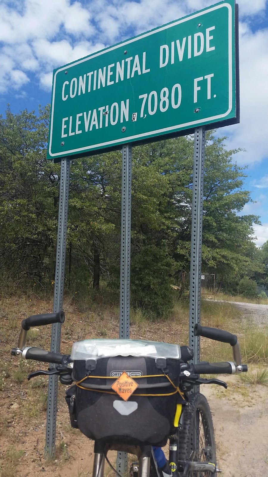
Last continental divide crossings, #30?
Total miles ridden - both on and off route
2485

This is it, my last day of riding the route, for this year at least? The long journey nears it's completion and I am ready for this milestone.

It rained last night and it is overcast as Glenda drops me off. The land here is a broad flat valley, with yucca, mesquite  and creasote bushes. I roll through the almost abandoned village of Hachita, and stop at the cavernous and empty community center, whose doors are open to Divide bikers and hikers to stay. This would have been my overnight last night if not for Glendas support.

I turn and peddle south from Hachita, taking in the desert and it's offerings. It is towards the end of the wet season here, and things are actually kinda green, in places. I see a frog!, some praying manti and hordes of a large type grasshopper working to propagate the species.

Big Hatchet Mountain dominates the views south. Big Hatchet grows as does my milage. I actually do climb a little around Big Hatchett, and a few other spots. On the other side of the Hatchet Gap, there are mountain ranges flanking both sides, and drifting south out of sight into Mexico, though they look barren, dry, and forbidding to me. I keep peddling, and pass a few widely spread ranches off in the distance.

I am counting the mile markers down, 40, 30, 20, 15, 10! Single digits are left! I start thinking, what are my top ten highlights of the trip? Much musing over the next hour or so helps me deal with the afternoon headwind. Probably worth a seperate post. Glenda passes me with about 7 miles left. I pass mile marker 5, I can taste it! The end is nigh, and the rest of life lies just beyond.

At last, there is the border station, and only the vorder staion; I am tired, jazzed, thoughtful, relieved, satisfied.
This trip is done, but upper Montana and a short section Wyoming remain and beckon,  and the divide stretches both north and south Canada and Mexico....

Thursday, September 29, 2016

GDT Day 53 - Silver City to Hwy 146

Thurs. Sept. 29, 2016,
 Silver City to Hwy 146, mile marker 9

Start - ~6100'
High pt  6200'
Lo pt. ~4400'
End Elv ~4400'
Climbing ~1000'??

Miles ~69.6
Total time 8:00
Ride time 6:50
Day with BOB 50
1 continental divide crossings, #29?

More blue sky greeted the day this morning, making me feel better about the long day planned.  I want to finish the remaining 125 miles of the route in 2 days instead of the three recommended in the guide. Glenda is with me now, and there is no camping on route for the trailer, so we have arranged a pickup where Hwy 146 starts the final 65 miles dash to Antelope Wells and the lonely border crossing there.

The day starts with a rolling and climbing18 miles of Hwy 90 through chapparell like landscapes with squat desert oaks spread apart at regular intervals.
I pass the giant Tyrone mine before getting to my turn to Separ and leave the pavement behind for 33 miles. There are now  more downs than ups, though sandy in places. It gets steadily drier and desert like as the route drifts further away from the consolidated mountain ranges. Soon the largest plants are yuccas to accompany me on this last section of backcountry. I see almost no one; except for one rancher, a road crew, and a sole border patrol jeep just outside Separ on I-10.

About 5 miles in on the dirt, I bag another divide crossing, though really the road and the divide follow a modest ridge together for several miles. Once again I look to the right and that leads to the Colorado River and the Pacific; to left,  the Rio Grande and the Atlantic. I marvel at the sameness of this ridge to many others, yet here in this spot it has this distinction.
I stop at the trading post in Separ and they offer me ice and water before I go.
Eight miles of dirt frontage road along I-10 brings me to the pickup point, and I am done with the dirt!!! The remaining portion of the route is a paved 65 miles of empty hwy to the border. It is still early, so I decide to knock out some more miles to shorten tomorrow's ride. Glenda catches up with me 10 miles in ( only an easy 9 miles to Hachita and some biker only camping), and shuttles me to Deming and the RV park, where dinner and a hot shower await in my short term future. I find I am tired  from the day and should sleep good tonight.

GDT Day 52 - Mesa CG to Silver City

Tues. Sept. 27, 2016,
 Mesa CG to Silver City

Start - ~6100'
High pt  7500'
Lo pt. ~5900'
End Elv ~5900'
Climbing ~2500'??

Miles ~30.8
Total time 5:00
Ride time 3:40
Day with BOB 49
1 continental divide crossings, #28 ?

The day off exploring yesterday was cloudy with occassional rain showers, indeed there was the pitter patter on the roof of camper as we went to sleep last night.
This morning, it is partly to mostly cloudy, but no rain. I decide to drop the trailer and ride the single track CDT alternative.
This has me back tracking a few miles until I leave the hwy, and all people as it turns out, behind for 12 miles. Along the way I see dozens of turkey vultures roosting in a dead tree, amazing.
The trail starts off as a ATV trail and climbs up the ridge along Skates Canyon. I find the cairned single track turn off, and have to double check, as it is not a well worn trail, and looks a little dodgy. A little ridge riding around Skates brings me to a long gentle up hill stretch rising with the mesa terrain. It is pretty green up here and while the trail is cairned in the juniper, pinon and yucca forest, the cairns are mostly hiding in grasses. The trail is lightly used and faint for long stretches, with rounded and broken lava rock generously applied. I have to hike a bike 3 or 4 times due to loose rock.
It is lightly used, and I see no one, see no signs of man, other than the trail and its markers. I finished the single track portion in another healthy ponderosa forest, and take series of forest roads out to meet the paved route near the top of a climb. A long down hill and modest climb takes me to Pinos Altos, a small mining town who's main street is a forgotten link to the old west.
Just out of town is another divide crossing, and then 8 swooping downhill miles to the city of Silver.

Wednesday, September 28, 2016

GDT Day 51 -Black Canyon to Mesa CG

Sun. Sept. 25, 2016,
Lower Black Canyon CG to Mesa CG

Start - ~6750'
High pt  7900'
Lo pt. ~6100'
End Elv ~6100'
Climbing ~3000'??

Miles ~30.5
Total time 6:30
Ride time
Day with BOB 49
2 continental divide crossings, #26 & #27 ?

It is cold this morning, and the sun is slow to shine in on the valley. Added to that, the fill in my sleeping bag has migrated to my feet, leaving my upper body uncomfortably cool just before dawn. I add to my morning chores a massage for my sleeping bag. However, this may be my last night tent camping as I am meeting Glenda today, and some pangs of regret are felt, as well as anticipation of completion of this long ride.

The day turn out to be another great sunny, breezy autumn day, if a little brisk.
The riding starts with more steep Gila twisty turny climbing out of the valley. I gain the ridge which evolves into a gently round and rolling mesa, covered with juniper, aligator juniper, some gnarled live oaks and pinons! After some rolling climbing, it is down down down steep, rocky, tortuous twisty descent into Rocky Canyon.
I stop at the boot on to check the nice CG, and who should drive bu a Anthony from the work center 2 days ago. He stops and chats, and I see that he has a few flowers pucked. He ask whete I sm headed to day. When I tell him I am mertong glenda ay mesa CG on lake Roberts,  he says he is too, to pick up his brother who is fishing there. He offers me some elk, and ask what kind of vehicle we have. What a generous guy. I profusely thank him for his kindness, and he says no problem, it help propel him forward in life. A true trail angel.

I restart my ride and next verse is same as the first, and that should be the last big climb for today. When I reach the mesa top, I start scouting for pinons, and I stop a number of times to collect nuts.  Thus I slow down my day, but weather is good, and I will be meeting Glenda at the CG. Also road is better than yesterday, with the fresh and deep gravel missing today. The views from the top show seemingly endless ridges and the varigated  mesas to higher peaks off in the distance to the south. And the east. And the west. This is a very large, mostly untrammelled area surrounding the route.
I crossed the divide again on my way down; gently at first and into steep winding switchbacks as I descend towards the Mimbres valley. I gain Hwy 35 for 8 fast miles through more healthy forest and open ranchlands, complemented by rising red cliffs as I head down valley. While it is Sunday afternoon with perfect weather, and I am heading to recreational Lake Roberts, there almost zero cars on the road as I cruise to my meet with Glenda.

Glenda had met Anthony and his brother Angel, and we now have an elk steak, a roast, and also 2 trout Angel caught for dinner.
We cook fresh fish this night, what an end of a wonderful day.

GDT Day 50 - Beaverhead Work Center to Lower Black Canyon CG

Sat. Sept. 24, 2016
 Beaverhead Work Center to Lower Black Canyon CG

Start - ~6750'
High pt  0'
Lo pt. ~0'
End Elv ~6580'
Climbing ~2000'??

Miles ~26
Total time 6:00
Ride time 4:15
Day with BOB 48
?? continental divide crossings

Sir strip
Bike repair tubes, tire, fender. Flag
Tried for some nuts
Wall lake
List straps
Upupup, DOWN
soft road, where not rocky
Empty campground
Interesting forest
Healthy ponderosa, oaks, alligator juniper

Today is a short day milage wise, bit it is also noteworthy as I get into the much discussed Gila mountains proper, with their many twisty climbs and descents.
The ridges and mesas are so varigated, with many mellow little drainages and valleys punctuated with occasional steep canyons, that milage is not the only measure of challenge.


It is another sunny morning, though chilly. It was cloudy and spitting rain on us last night, but this morning the clouds are belowus, as fog in the flat valley only a wee bit below. After switching out tires and tubes, checking the trailer repair, and reattaching the trailer fender due to a fender plastic tear, I get a late start. The weather is a perfect autum day, with a mild wind to keep me humble. It rolling up and down, sometimes steeply, with tons of frsh gravel.to soften the road, to get to Wall lake, which is guarded on one side by a good looking cliff. Then I begin a sustained, yet mellow climb up though a series of drainages, holding incredibly healthy ponderosa forests. I begin seeing oak trees of good size, which I normally don't associate with ponderosa forest coming from Colorado.
I eventually gain a ridge line and head down, and then do it again. And again. And yet again. Next verse, same as the first. Some times I gain ridges and descend quickly, other times it is sustained time on a mesa. It is drier up here with juniper, aligator juniper, pinon, and anothw different oak species, with small ovall leaves, apparently adapted to the dryer conditions. Many of the pinons are heavy with cones, that are heavy with nuts. Weather and time is good, so I stop to collect pinon nuts along.the way here and there when the trees have laden cones I can reach.

I have been seeing wooly caterpillars on the move over the last week or so. I do not pretend to understand what kind of winter that portends, but I think it is telling me to get a move on and finish this wandering adventure I am on!

The route is going through a narrow corridor between two large wilderness areas; the Gila and the Aldo Leopold. My last steep rocky descent takes me to to my destination.

The campground is on the floor of the Black Canyon, a wide spot that is a meadow with a stream. Given it is essentially surrounded by wilderness, it has not been grazed. It is pretty green from the wet monsoon season -  I think to myself (ok, so maybe I spoke out loud, I have been riding by myself alot), so this is what it should look like. I also saw the same effect in a much larger valley bottom earlier. I have seen damn few places like this along the route, but I guess I have also been enjoying the occasional burger along thw way too.....

This stream also supports the Gila trout, a unique species that can tolerate much warmer water (80 degreesF) than those found further north.
While the meadow is not over grazed by cows it is also only lightly used by humans and the campsites are overgrown. I am alone again tonight, just me and the woodpeckers. I set my tent up under a giant oak tree, the likes of which I have not seen in western mountains further north. It watches over me as I sleep, dropping an occasional acorn on my tent to tease me, and to remind me as to whose meadow it really is.